Posts: 1,263
Threads: 45
Joined: Feb 2010
Hope this is the right place for this. While looking at industrial spurs in the Denver Colorado area this evening, I found these interesting views on Bing Maps on E 37th St in Aurora, CO. Looks like those two 86 foot box cars didn't handle that curve very well...
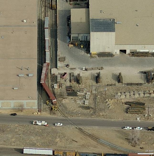
This view (looking West) appears to have been taken shortly after the derailment

In this view (looking North) the UP track gang is on the scene to get the cars rerailed
Guess we can all relate to something similar to this on our model railroads...
Ed
"Friends don't let friends build Timesavers"
Posts: 3,683
Threads: 118
Joined: Jan 2009
Wow, what a cool find! Awesome! Google Earth and Bing Maps are amazing!
Something else I find interesting is that the two bird's eye views of this were taken around the same time. I find that the various views were taken at different times, with different train cars and even different seasons, so when you do the rotate views, things change.
On further look, the two gons are gone in the second view.
does anyone know, are these views taken from airplanes or from sphisticated cameras in satelites? I'm thinking it has to be planes to get the different angles so close together in time.
Three Foot Rule In Effect At All Times
Posts: 1,263
Threads: 45
Joined: Feb 2010
Gary;
Pretty sure that the Bing "Birds Eye" views are taken from aircraft.
Another thing that I've noticed happen, is often when following a rail line, when I pan back to a previous location, the view will be completely different then when I first went over the same area. Then I can pan back again and get the original view. Can't quite figure that one out.
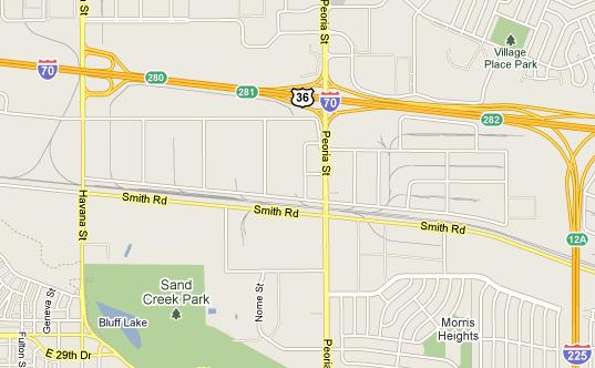
I've noticed that the satellite images on Google are usually of a better quality than Bing, not to mention the road map view. Bing does not show rail lines on their map views with the detail that Google does, so if you're using the road map view of Bing, you are very likely to pass up interesting rail areas.
Examples of what I mean are the area where I found the derailment...
Here's the Google Road Map
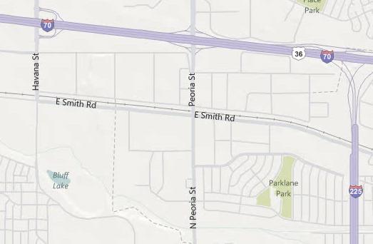
And the same area in Bing Road Map
In either case, the satellite images are dependent upon individual states. For instance, satellite views in Indiana are so good you can almost count the ties on the track any where you view a rail line in the state. In my home state of Kentucky, you only get quality images like that in the most populated areas, the rest of the state the quality is very poor. I just wish that the Bing "Birds Eye" views were available everywhere, but guess that will come in time.
I've also found the Google Street views to be very handy where available. If the street view is available on a street that runs next to or through an industrial park, you can really get some good detail views of the structures, etc.
Ed
"Friends don't let friends build Timesavers"
Posts: 3,683
Threads: 118
Joined: Jan 2009
So where do I find the google "street view"?
Three Foot Rule In Effect At All Times
Posts: 1,263
Threads: 45
Joined: Feb 2010
Gary S Wrote:So where do I find the google "street view"? Gary;
When you are on the Map View in Google and Street View is available, you'll see some of the streets in Yellow. Click on the little Man icon and drag him to the Yellow area and it will go into Street View. You can then follow the street - change the view, etc. Pretty neat at times.
Here's an example of what I'm describing...

You will find the Street View available in a lot of areas, but often just on the "Main Drags" in town. Give it a try...
I've run across some interesting things in that Street View mode. For instance, I was looking at an industrial spur in Marietta, Georgia, using street view and discovered that the last industry on the spur, used a TrackMobile to spot their cars. You could see the TrackMobile just inside the building. When I switched to the satellite view, I then noticed the TrackMobile in the parking lot of the industry which I hadn't noticed before.
Ed
"Friends don't let friends build Timesavers"
Posts: 454
Threads: 18
Joined: Sep 2010
Interesting, in my part of the country I find Bing and the bird's eye view to be MUCH more useful - outside of major cities like Philadelphia they just don't have street views yet, but they DO have Bing bird's eye views. Plus when I enter a known address, Bing points right to the exact spot, Google is usually in the right block but that's about it. I used Bing birds eye views to follow the branch I am modeling and try to get the track arrangment as close as I could in my limited space.
--Randy
Posts: 1,263
Threads: 45
Joined: Feb 2010
Randy;
When I want to explore an area, I use both Google and Bing. I first use Google map view to locate the rail lines - MUCH better than Bing - then I'll use satellite view in Google to look over the area and if it's interesting then I'll switch between Google satellite view and Bing birds eye view (if available) for detailed looks. As mentioned, I find the Google street view very handy at times. Using both Google and Bing, gives you more possible features then just using one. It's also often handy to look at specific areas on topo maps too.
Ed
"Friends don't let friends build Timesavers"
Posts: 1,797
Threads: 81
Joined: Dec 2008
Actually when you drag the little dude in Google Maps to any street that automatically highlights in a blue outline when the little dude hovers over it you can see the street view of that specific location. Yellow just indicates a major city street.
Posts: 3,683
Threads: 118
Joined: Jan 2009
Thanks for that info. I haven't seen that before because I have only used the google earth satelite view. I'll check it oout tomorrow.
Three Foot Rule In Effect At All Times
Posts: 1,263
Threads: 45
Joined: Feb 2010
tetters Wrote:Actually when you drag the little dude in Google Maps to any street that automatically highlights in a blue outline when the little dude hovers over it you can see the street view of that specific location. Yellow just indicates a major city street. Tetters; You're quite right! My mistake based on sometimes the "little dude" wouldn't work on every street, but does if the street highlights in blue. Here's example of things you can find using the street view...
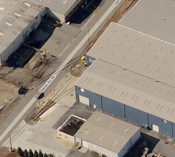
This is Metal Coaters of Georgia on Damar Rd, Marietta, GA and in Bing birds eye view facing West...
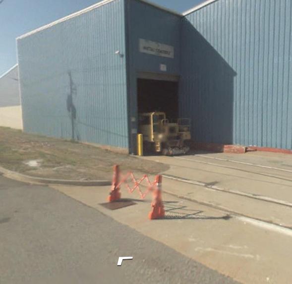
Combination of Google and Bing sure is handy for checking things out!
Ed
"Friends don't let friends build Timesavers"
Posts: 3,262
Threads: 115
Joined: Dec 2008
Ed:Combination of Google and Bing sure is handy for checking things out!
---------------------
One of the best research tools on the net.
Larry
Engineman
Summerset Ry
Make Safety your first thought, Not your last! Safety First!
Posts: 931
Threads: 68
Joined: Dec 2008
Slightly OT, but go to Bing Maps and type in Marr Ave NW, Marietta, GA 30060 The map should show two tracks curving in a V formation You are interested in the one that cuts Marr Ave NW. Focus down and select Birds Eye Hit the right curved arrow once (so you are looking from the west), and close right in - is that a scrap yard, or storage, or what? Different views show different numbers of locos and wagons
This is what you should see
![[Image: queryd.jpg]](http://img153.imageshack.us/img153/4058/queryd.jpg)
Typing the same address into Google and going to Street View gives some more, interesting views
Posts: 1,263
Threads: 45
Joined: Feb 2010
shortliner Wrote:This is what you should see
![[Image: queryd.jpg]](http://img153.imageshack.us/img153/4058/queryd.jpg) What you are looking at is the headquarters of the Georgia Northeastern Railroad http://www.gnrr.com/. Short line operating the former L&N "Hook and Eye" line out of Marietta. Pretty sure that the two buildings you see and the trucks belong to them. As you noted, different views show different details. In one view, looks like their entire locomotive fleet is in the "yard"....
Ed
"Friends don't let friends build Timesavers"
|


![[Image: queryd.jpg]](http://img153.imageshack.us/img153/4058/queryd.jpg)